There are only a few things that frustrate me about traveling, and one of them is the guide book. Don’t get me wrong — there’s a ton of value to a guide book and I’d never leave home without one; but really, it’s not the book that’s of value but the content inside that book. In this day of a ubiquitous iPhone or Android-powered device, tell me why I should carry a 5 pound monster everywhere I go?

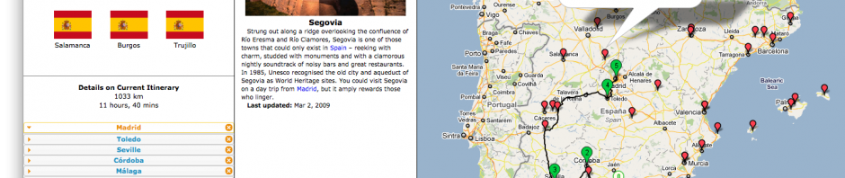
A screenshot of the Itinerary Buidler prototype tool I've written, available at http://pariser.me/itinerary
This is the realization that led me to build a prototype tool, which I’ve blandly named Itinerary Builder (http://pariser.me/itinerary), with the hope of re-conceptualizing the format of a “guide book”, at least for the planning stages of a trip.From an usability perspective, the constraints placed on the print guide book make it less than ideal.
First, the size of a guide book alone is problematic–they’re way too heavy, and I suspect editors are required to spend many waking hours suffering over decisions of which of places make final print and which are relegated to die at the draft table just in order that they not exceed a page limit. I’m not too unhappy about this selection process, though, as I think most value provided by a guide book is it’s curated list of travel suggestions.
So then there is the more important and fundamental problem for a print guide book–the problem of context. Geographic proximity is often the rule for content placement, though there is no assurance that users of the guide book consume sections of the book in the order dictated by geographic proximity. I am confident that many travelers have gone directly from Berlin to Munich and had to jump 52 pages through a guide book (or 974 pages, with a detour at the Table of Contents). It’s an even longer journey to cross a country border when in one of the multi-country guide books.
While I don’t suggest for one second that we should get rid of the print guide book (it has the indispensable value of providing information without the need for a charged battery, power cable, or internet access), I do think we can make planning a trip easier.
Itinerary Builder provides an interface for a user to choose a collection of cities (s)he may want to visit on a vacation. My prototype is one of these newfangled “mash-up” projects, which combines information from Lonely Planet, Google driving directions and Google geo-location services to be used with a route visualization drawn using the Google Maps APIs. While using this tool, a user manages the stops on the itinerary (with drag-and-drop re-ordering) and is suggested a list of “next” destinations in the top-left of the screen. (The system never recommends that a user should go to a destination they’ve already visited; currently, the recommended next destinations are ordered by proximity, but the system could very well use information about “most traveled” or even “least traveled” routes.)
When clicking on a destination city, either on the map or inside the suggested list of cities, an information box is opened with the Lonely Planet description of the city, giving the user information that entitles them to make a decision about whether or not they should visit; if so, they can click the link “Add as next destination in itinerary”. Information about driving distance from the previous city is provided as a hover tool-tip when mousing over another city, suggesting e.g. that Salamanca is a 2.5 hour, 213 km drive from Madrid. Additionally, the calculated aggregate distance and time needed to travel between cities is updated and displayed to the user as they change the itinerary.
There is much more that can be accomplished with a tool of this type. Imagine planning a trip, deciding to visit Madrid on a Monday, and being alerted with a message that tells you that the Prado is closed on every Monday! Consider a system that helps you figure out the best combination of types of transportation to make your intra- and inter-city travel as seamless as possible. One of the great suggestions by colleagues in the Data Visualization class for whose final project I built this tool was to allow a user to set a time budget and be provided with suggested itineraries, i.e. suggesting answers to the question, “I’ll be entering City A on day X and departing from City B on day Y; what should I do [with the following constraints]?”
Please give me feedback! I’d love to hear if you would use this, and how. I especially hope you will use my prototype if you are planning a trip to Spain. If you aren’t planning a trip to Spain, well, shame on you. 🙂